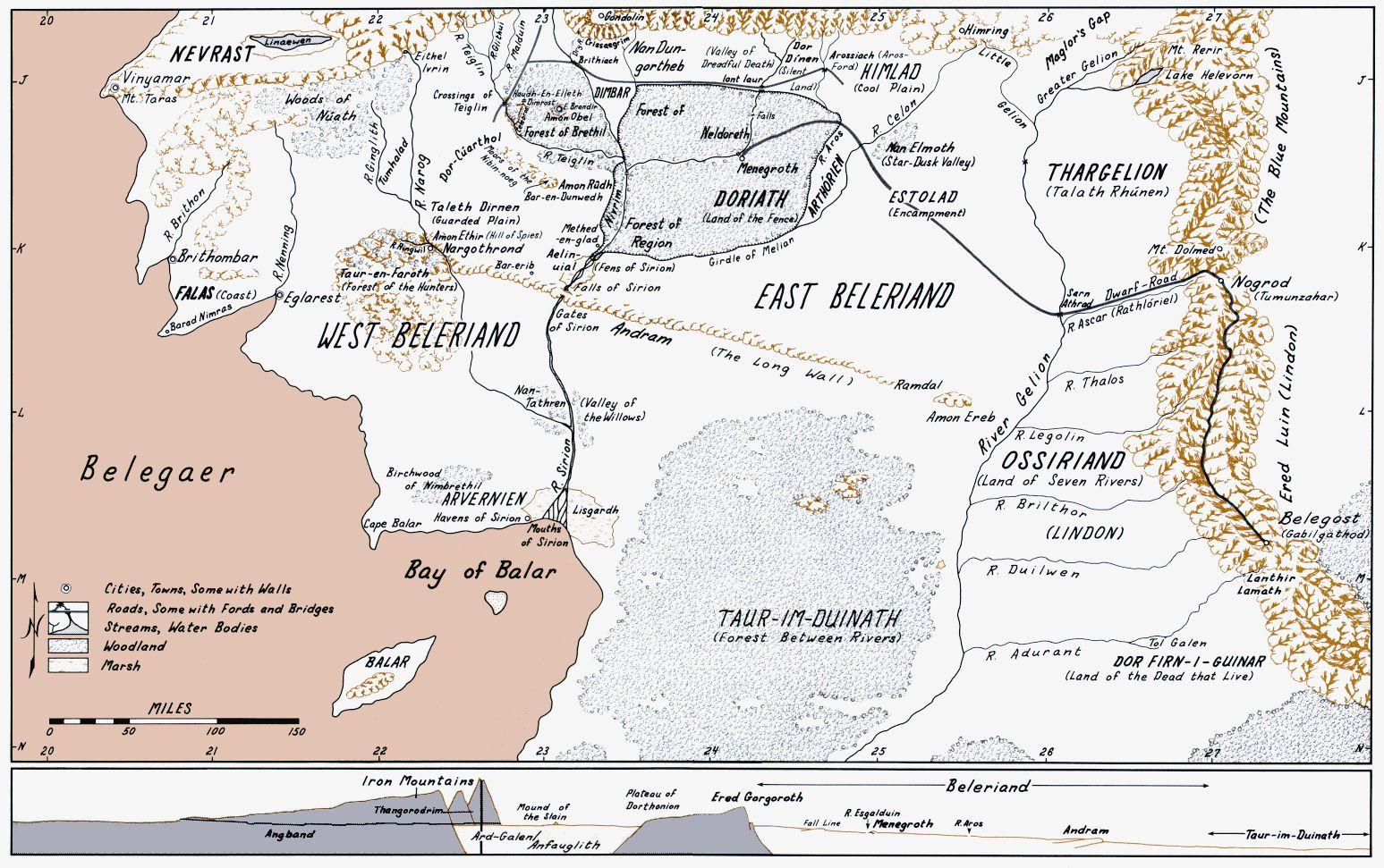
Where exactly is this?
This Is just west to the Shire. Read the Silmarillion
See the mountain range Ered Luin? That gives it away. The Shire has that on its western border.
Where exactly is Angmar in the Third Age?And everything from the First age in a Third Age Perspective…
I guess its next to Himling 😐
I love this.
This is S.Beleriand. Everything west of the Ered Luin sank under the sea at the end of the First Age.
The Grey Havens were built, after the Isle of Balar sank, by CÃrdan and Gil-Galad.
The approx. spot for Angmar would be to the right of area J on this map.
When the land was reshaped by the War of Wrath (end of F.A.), the Blue Mtns were broken and a new Gulf was
created north of Belegost (the only Dwarven city to survive the upheaval), about 2/3 up from M to L.
The Gulf of Lhûn is where Gil-Galad created Lindon and CÃrdan the Gray Havens. Lindon was abandoned when Gil-
Galad died at the end of the Second Age. CÃrdan kept the Grey Havens going so that Elves to go home to Aman.
Too crowded.
THIS IS BELERIAND AT THE TIME OF THE SILMARILLION!!!!!!! (i think)
ssssswwwwwwwwwwwwwwweeeeeeeeeeeeeeeeeettttttttttttttttt
you guys are wrong about this being west of the shire, and about the location of Angband.
this is the SOUTH half of Beleriand, so it’s SOUTH-west of the Shire
and Angband is way to the north of the mountains at the very top edge
I think it is very well done. A lot of time and effort has gone into this.
You must be logged in to post a comment.


20 Comments
Where exactly is this?
This Is just west to the Shire. Read the Silmarillion
See the mountain range Ered Luin? That gives it away. The Shire has that on its western border.
Where exactly is Angmar in the Third Age?And everything from the First age in a Third Age Perspective…
I guess its next to Himling 😐
I love this.
This is S.Beleriand. Everything west of the Ered Luin sank under the sea at the end of the First Age.
The Grey Havens were built, after the Isle of Balar sank, by CÃrdan and Gil-Galad.
The approx. spot for Angmar would be to the right of area J on this map.
When the land was reshaped by the War of Wrath (end of F.A.), the Blue Mtns were broken and a new Gulf was
created north of Belegost (the only Dwarven city to survive the upheaval), about 2/3 up from M to L.
The Gulf of Lhûn is where Gil-Galad created Lindon and CÃrdan the Gray Havens. Lindon was abandoned when Gil-
Galad died at the end of the Second Age. CÃrdan kept the Grey Havens going so that Elves to go home to Aman.
Too crowded.
THIS IS BELERIAND AT THE TIME OF THE SILMARILLION!!!!!!! (i think)
ssssswwwwwwwwwwwwwwweeeeeeeeeeeeeeeeeettttttttttttttttt
you guys are wrong about this being west of the shire, and about the location of Angband.
this is the SOUTH half of Beleriand, so it’s SOUTH-west of the Shire
and Angband is way to the north of the mountains at the very top edge
I think it is very well done. A lot of time and effort has gone into this.