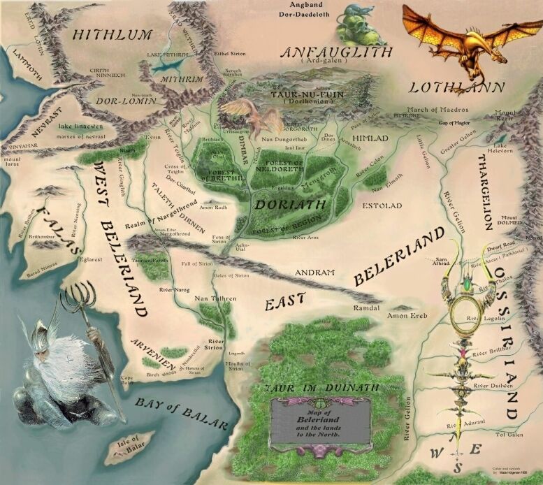
Is this M.E.? North M.E.?
err I think — but don’t quote me on this — that this is what once was in what’s now the Bay of Belfalas. All
the cities of Beleriand were destroyed, one by one, before Gondolin fell…I think…I could be wrong…?
see, I *think* the mountains on the right-hand side are the Encircling Mountains, part of which hid Gondolin..
…before it was betrayed *mutters about betrayal* Umm…I’m probably a bit off here…anyone else?
gondolin is in the area where that small eagle is
This is by far the best Map of Beleriand. in another post i said that This is Just to the west of The Shire.
you’re right, Galadoreen, the mountains on the west are the Ered Luin ( the Blue Mountains),
and they are shown on the left of the Middle Earth maps
oops! sorry… I just wanted to say that the dragon is AWESOME!!!! and the fish guy too
Wonderful map, much better than the one found in the Silmasillion. Where do you have it from, Lord Elendil?
This map is representing 1st Age of Arda. See more in Karen Wynn Fonstad’s “The Atlas of Middle-Earth”.
this is a severely different map from the one i have. i think this is a former version…tolkien was always…
…changing the geography and details. this is what middle-earth looked like before the drowing of belariand.
This map is wonderfully done! Must get that book.
what book is this from?
wow! who drew this? And rico, the fish guy is probably Ulmo?
Wow, great map!!!
whoops accidental empty post sorry. hehe fish guy.
Great map,simply great…
Whose the dragon? Ancalagon? Must be. Why is he depicted there?
Beautiful map indeed!
Is the “Fish Guy” Ulmo?
You must be logged in to post a comment.


24 Comments
Is this M.E.? North M.E.?
err I think — but don’t quote me on this — that this is what once was in what’s now the Bay of Belfalas. All
the cities of Beleriand were destroyed, one by one, before Gondolin fell…I think…I could be wrong…?
see, I *think* the mountains on the right-hand side are the Encircling Mountains, part of which hid Gondolin..
…before it was betrayed *mutters about betrayal* Umm…I’m probably a bit off here…anyone else?
gondolin is in the area where that small eagle is
This is by far the best Map of Beleriand. in another post i said that This is Just to the west of The Shire.
you’re right, Galadoreen, the mountains on the west are the Ered Luin ( the Blue Mountains),
and they are shown on the left of the Middle Earth maps
oops! sorry… I just wanted to say that the dragon is AWESOME!!!! and the fish guy too
Wonderful map, much better than the one found in the Silmasillion. Where do you have it from, Lord Elendil?
This map is representing 1st Age of Arda. See more in Karen Wynn Fonstad’s “The Atlas of Middle-Earth”.
this is a severely different map from the one i have. i think this is a former version…tolkien was always…
…changing the geography and details. this is what middle-earth looked like before the drowing of belariand.
This map is wonderfully done! Must get that book.
what book is this from?
wow! who drew this? And rico, the fish guy is probably Ulmo?
Wow, great map!!!
whoops accidental empty post sorry. hehe fish guy.
Great map,simply great…
Whose the dragon? Ancalagon? Must be. Why is he depicted there?
Beautiful map indeed!
Is the “Fish Guy” Ulmo?